USTravel

Castle Dome Ghost Town, Arizona

In our continuing futile search for warmer weather, we moved our home just as far as we could go and still stay in the United States – to Yuma, Arizona. If we had gone any further south we would have been in Mexico. Our RV park was only fourteen miles away from the border.

While in Yuma, we had an incredibly interesting and fun day at Castle Dome Ghost Town.

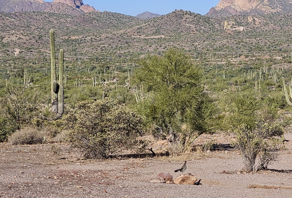
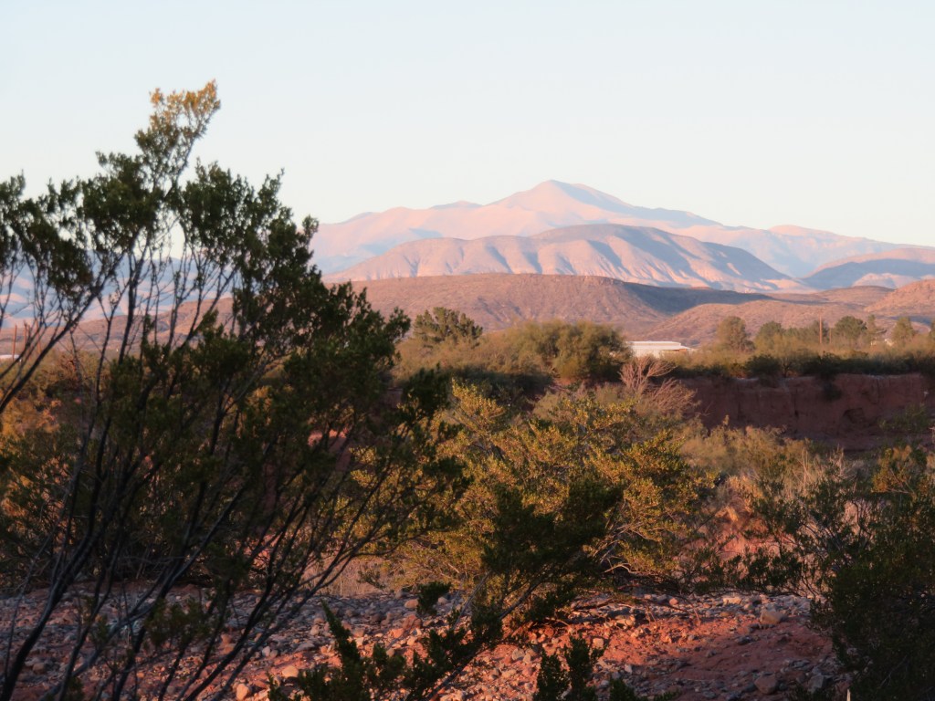
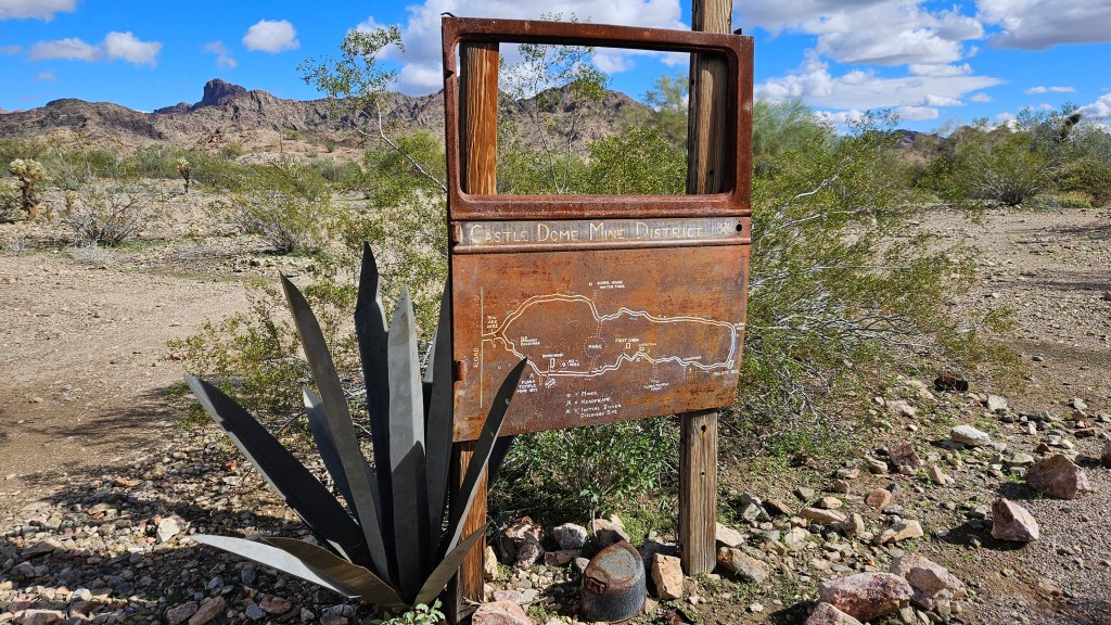
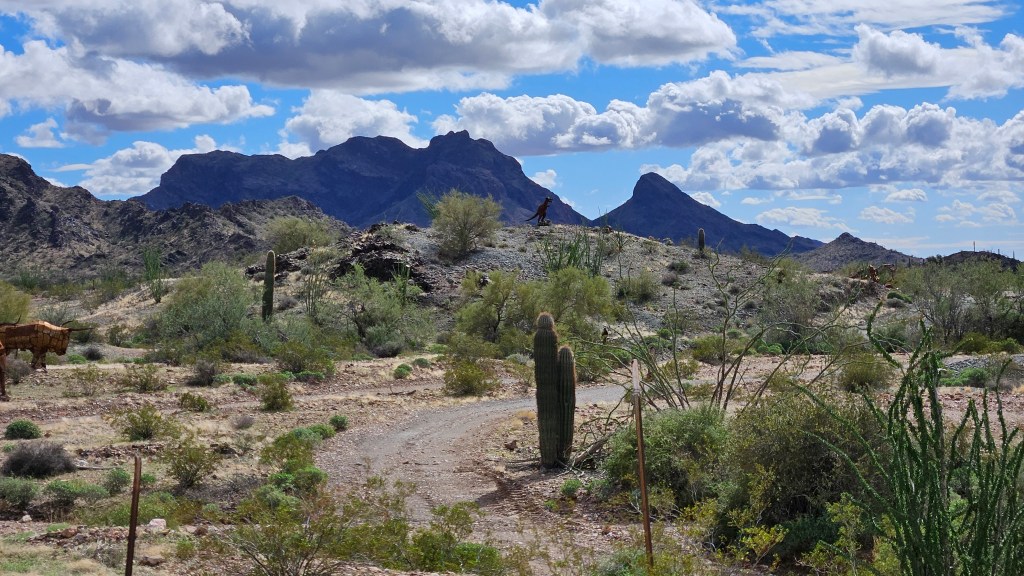
The town takes its name from the mountain range behind it. Castle Dome is the peak that looks a bit like a knob on top of the peak on the left. We could always see it clear back to Yuma. And I say “clear back” because it is a bit of a drive to get here. After the forty mile or so trip, there is a three mile stretch of pavement on the turnoff, and then about seven miles on a rough dirt road through Kofa Wildlife Preserve. A good ghost town is never easy to get to – at least not the ones we have seen.

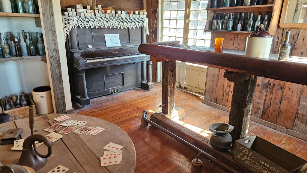
The actual name of this place, Castle Dome Mine Museum, is owned by a couple by the name of Stephanie and Allan Armstrong. They salvaged original town artifacts from the desert and the surrounding abandoned mines. Around 60 buildings have been resurrected and furnished. What I liked is that everything is open – no peering through dusty windowpanes here – and for the most part there are no display cases or ropes to stand behind.

Inside one of the many saloons, where a good card game has seemingly just been abandoned. I could almost hear the piano playing some old-time tunes.

Cal found a bigger saloon to hang out in. This one belonged to the hotel and stagecoach stop. Is that a ghostly apparition in the mirror behind him?

Meanwhile, I tried to work the cash register in the general store.

There were once over three hundred mines here, and this is the longest worked mining district in Arizona. Both silver and lead were mined as late as 1979. Galena was the primary ore and the minerals were extracted from the rock, but when silver prices plummeted the mines finally closed. There are other minerals too, including gold, but the gold mostly played out before the 1900’s. The late 19th century was the heydey of mining in Castle Dome.

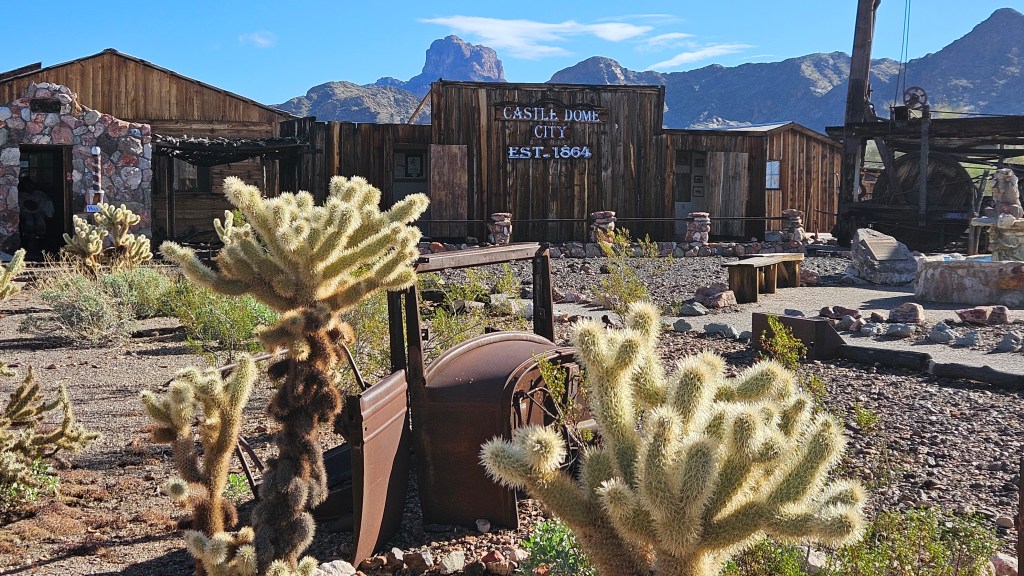
The town of Castle Dome was once larger than Yuma, and its main drag stretched for miles.

During and after the civil war, people came here in search of a better life. Other people were disillusioned by the California Gold Rush and came back east a bit to stake a claim. They would set up some cactus or tree branches from the desert, throw a blanket over the top, and call it home until their fortunes turned.

Tools of the trade

There were some areas that are restored back to the eras of the 50’s to the 70’s, since people were living here then, too. But I liked wandering a little further out from the restored town and looking at remains that are still sitting the way they were left.

In case the sign is hard to read, this is the encampment of Rita, who came here in 1883 looking for “the right man”. She built the stone steps to her cabin and the rock pillar with which to do her cooking. She always had a pot of beans and cup of coffee at the ready, and all were welcome.

There are actually four mines in this picture. Can you find them all?

It’s possible to tour one of the mines in Castle Dome. I will admit that, to us, it is outrageously expensive at $70 per head, but we are on the road to see and do all we can. We decided ahead of time that we’d plunk down the money and not look back!

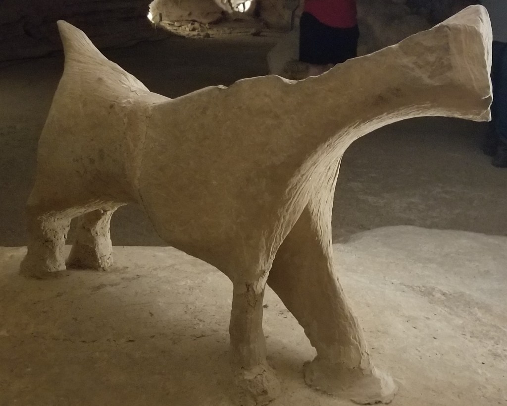
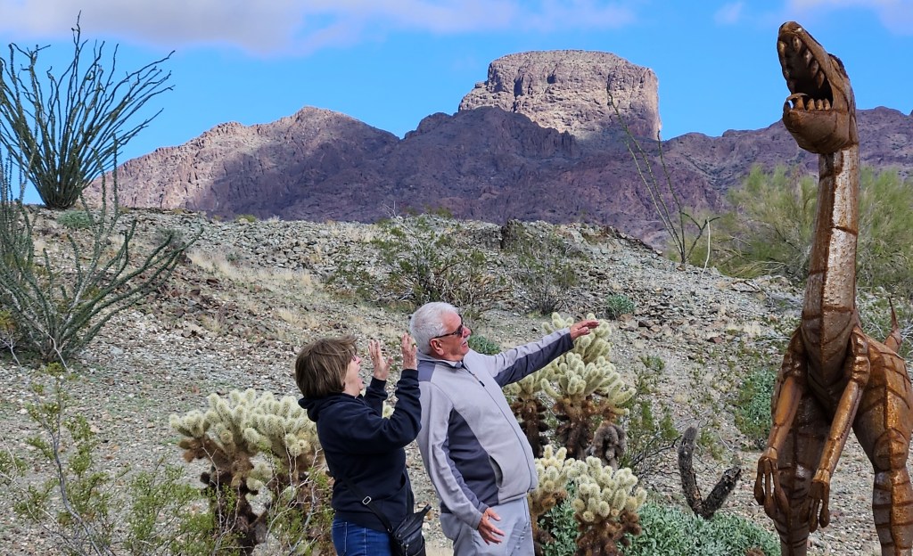
We were in a large golf cart with only three other people plus the guide for the mine tour, and he was a fount of information. And this is where it got a little weird. Turns out Alan, the owner, has come into the treasure of someone who is liquidating their metal sculpture business. It’s not something that is advertised, but they are being set up everywhere out back. In between listening to the bits of information our guide was giving us, there was this to look at:

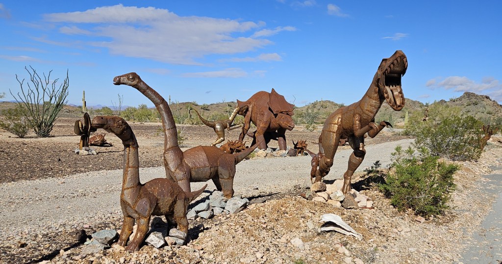
The pre-teen in our group was very impressed. I decided that this would really make the tour fun for kids (or adults) who might need a bit of a diversion from rocks and mining. And to be fair, there is more to the metalwork than just dinosaurs: there are animals and birds of the desert, a miners camp, and other scenes. Another adult in our group took picture after picture of the sculptures, so I guess she enjoyed them too.

We finally arrived at the mine and discussed mining equipment. While our guide was talking, I took a picture of the view. Just ignore the little coyote on the far right. It was impossible to take pictures without these things popping up.

Our golf cart went right into the mine, 100 feet down. We stayed on this level, but there are actually seven levels to the Castle Dome mines, and all mines feed into the main passageways. Out of the seven levels, five are under water. When the mines were in operation, the water was being continually pumped out.

Once down in the mine, we were out of the golf cart.

The mines are no longer in use because prices have dropped and the cost of extraction and production would erase any profit. We looked at this chunk of galena. It contains about 60% lead and 40% silver, and there is fluorite wrapped around it. Its value is estimated at about $5,400, but there would really be no value in processing it.

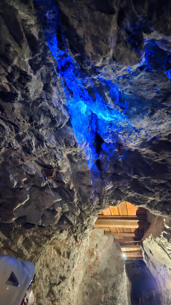
Our guide highlighted a vein of silver, which shows up more easily with his blue light.

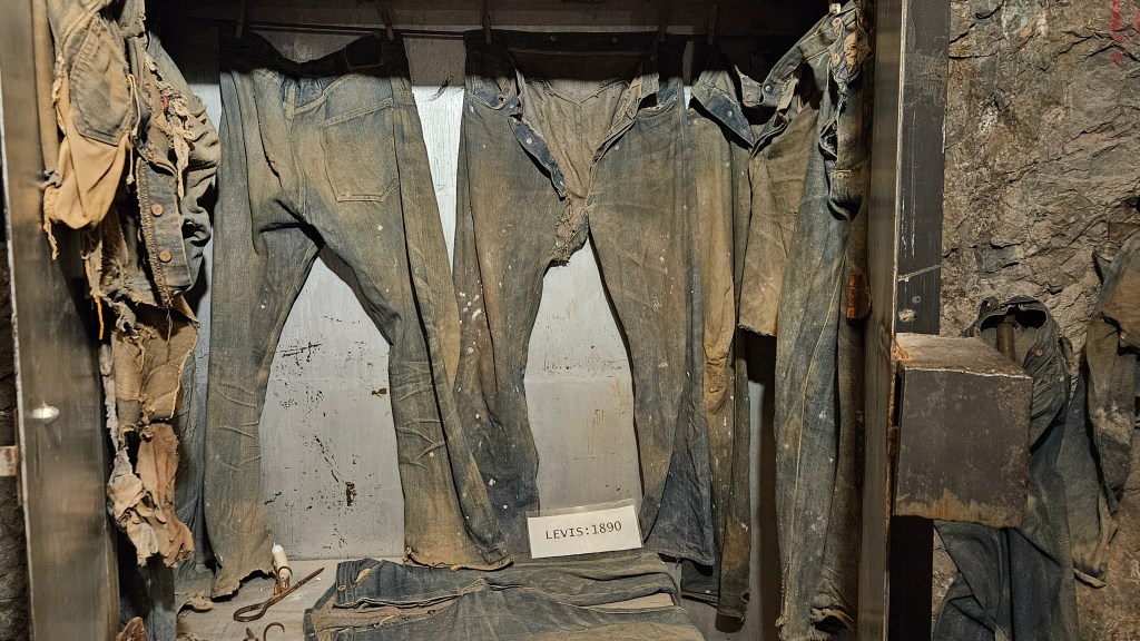
Besides the minerals, there is a treasure trove of items left behind by generations of miners. The climate of the mine preserves them perfectly. Outlaws hid their plunder down here, and there was once a blacksmith shop. Miners wore out their jeans quickly and needed replacements on the job, and many pairs have been found. We looked at some Levi’s that were over a hundred years old:

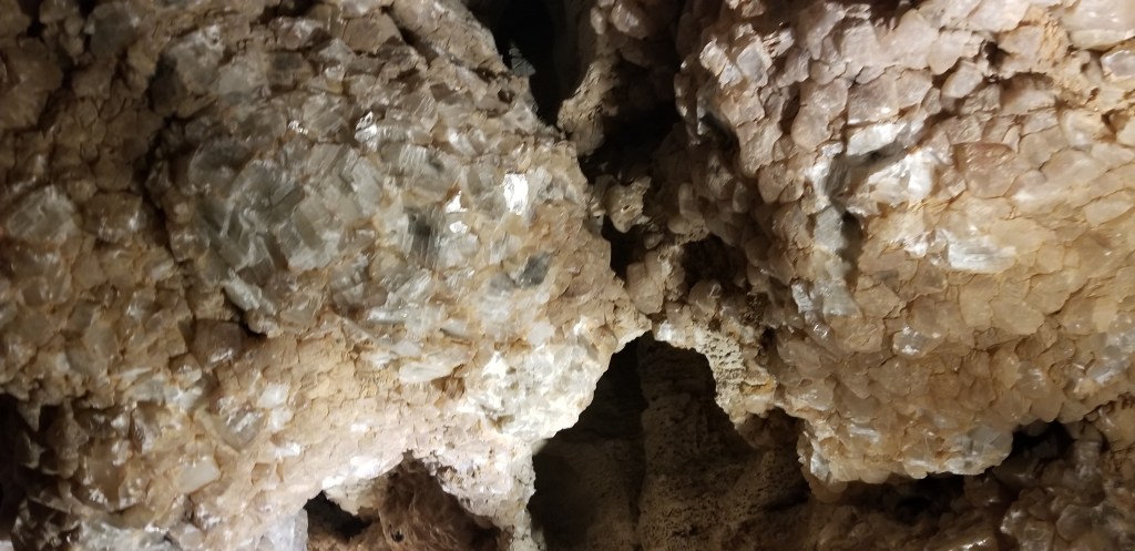
To us, the thing that made this mine absolutely worth what we paid for the tour was the view we received with the lights off and the high-powered black lights on. The mine is full of fluorescent minerals and these lights cause them to glow.

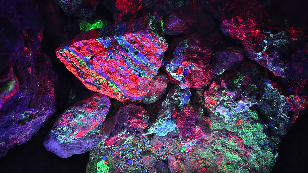
The reds are calcite or halite. Chalcedony, hyalite, or opalite causes the greens. The blues are mostly fluorite, but could also be hydrozinite. It is literally a feast for the eyes, each picture that I took a work of art. With the lights, the mine becomes a wonderland.

When our guide turned the lights off and we entered a totality of darkness, the rocks still glowed. They would continue to do so, he said, for about an hour.

This naturally-occurring “Karaoke Cat” was still glowing after the lights went out.

Our tour was done soon after that, because of course, the phosphorescence was the highlight. The tour lasted an hour and a half.

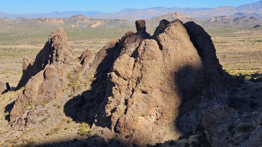
Inside the mine, our guide had discussed the shifting rocks that are pushing upward under the surface. Mountains were caused eons ago by this shifting rock. We could see the shape of the rocks that come together underground, and once above ground on the way back, could see the effect of those same rocks on the small hill in the picture below. Yes, the one the dinosaur is standing on.

Our guide stopped so we could have a little fun, too. He compared this to one of those tourist places where a picture can be taken with a fake background. Let me assure you, the background here is absolutely the real thing.

What a time we had here! If I’d loaded up all the pictures I took or enlightened you with all the other things I learned, we’d be here all day. So I’ll stop for now, and maybe do one more post about our stay in Yuma later.

Next time – what’s in your salad bowl?

USTravel

A Desert Stay at Lost Dutchman State Park, Arizona

The Twosna Travelers hope you had a merry Christmas, happy holidays, and a happy New Year, where ever it was you celebrated!

I have been a little quiet this past month on this blog. It was partly due to the holidays, partly due to relief at having finally finished my Europe blogs, and definitely due to Internet issues at the park we were at. This was not an inexpensive park; why was it so difficult to connect? Or, was it because my computer is now seven years old? Adding to this, the cable for our new phones will not fit my computer. This is how I transfer pictures. I can upload from Google Photos for now, but I’m probably going to have to address this sooner than later. If anyone has good ideas for me, I’m all ears.

For the third year in a row, we beat it out of Denver on November 1. There were several nightly stops in New Mexico but we did not stick around long; it was too cold there last year. This desert spot at Lost Dutchman, outside of Apache Junction, was our first destination. The warm sun was balm to our bones after the cooling temperatures in Denver.

It may not look like heaven, but perhaps a different perspective will change your opinion. We were situated in direct view of the the gorgeous Superstition Mountain range.

Every time I went for a walk around the campground loops, I would catch sight of several Gambel’s quail or at least one roadrunner, and I loved being back in the saguaro cactus forest. You can see a roadrunner on the rocks at the bottom of the picture below.

We came to Lost Dutchman to retreat, unwind, and hike. Our best hike was up in the shadows of the mountain on the Treasure Loop trail. We passed stands of other-worldly cholla on the way up.

Now, we could see close up the rock formations we had wondered about from our lawn chairs the night before.

The trail is also enjoyed by horseback riders.

Up at the part of the trail with highest elevation, we could see Phoenix in the distance and more mountains beyond. The city lies inside a ring of small mountain ranges, and the entire Phoenix area is known as “The Valley”.

Also at the top were weird rock formations–

and behind us, tucked into the mountain’s wall, a natural arch. It is on the right side of this picture.

If I ever make a list of the “Ten Favorite Things I’ve Learned While RV’ing”, one of those things would be this: that the setting sun on one horizon bathes mountainsides on the opposite horizon in a red glow before sunset. We first witnessed this at Big Bend National Park in Texas, and we have seen it in several places throughout the Southwest since then. It is a sight that thrills us every time, and the Superstitions were no exception. We pull up our lawn chairs for the brief show.

Compare this picture of the Superstition sunset glow to the daytime Superstition picture I posted above.

We never tire of this sight. We moved from here to an RV park where we could still see the Superstitions, and it has become one of my favorite mountain ranges.

Next time: horsing around by the Salt River

Life in General · USTravel

“Home” Again in St. Peters, Missouri

We left this place two years and two months ago to begin our full-time RV life, and haven’t returned. It was exactly a year after the Covid pandemic began. Cal was happy to finally be leaving the Midwest. I was happy to be off on our new adventure. Life has taken us elsewhere, but a special wedding brought us back.

The RV park in which we stayed in for the week, 370 Lakeside Park, is one that we visited many times when we first purchased our RV. It was close to our apartment. As soon as we received a wedding date, I was on the phone and booking my coveted spot.

This is in the back row of the park closest to the lake and the bike path. Score for me! I had never been so lucky as to be able to book this when we had previously stayed.

As always, the geese are here in plentiful numbers.

The wedding was for our godson, Chip, and his bride Jessica. It was held at our former church in Florissant, and the reception was in downtown St. Louis. We had a great time and wish them well in their new life.

Chip and his siblings, Shannon and Megan, grew up with our daughters.

Chip’s parent’s, Kris and Rusty, are our good friends and we were happy to see them again.

As it got dark, the lights in the reception room reflected outside the window, together with the full moon, for a surreal picture.

After the wedding events were over, we spent time with my sister Diana, my brother-in-law John, and their daughter Melissa and her family. We met Diana, John and their granddaughter at Blanchette Park, where there are some pretty gardens.

From Austin to St. Peters, we experienced spring over and over!

Clarissa, Diana and John in the gardens. It was a hot afternoon and we didn’t stay long.

And then…my blogging world met my real world. We had a lunch date with Betty and Dan Chambers. Betty has been one of my best followers on this blog, usually leaving thoughtful comments on what she has read. She also writes her own engaging blog, Chambers on the Road. I enjoy reading that, and in the past few months she has gone a step further and written an an e-book: RVing with Bikes.

We met at a little lunch restaurant, Lady Di’s, and were still visiting when the place closed for the afternoon! There was so much to talk about. We were on the patio, so we were able to stay long past their closing time. Although we had just met in person, it felt as if we had been friends for a good long while. They have kept their home in the area, but they like traveling with their RV and enjoy their e-bikes.

The week was a whirlwind of many family and friends to visit. One day I ate all three meals in restaurants or had carryout with three different groups of people. We saw many old friends from our church, and I also had a lunch with my former colleagues.

We decided to take one day out on our own to visit the aquarium and wheel at Union Station in downtown St. Louis. Both opened back when Covid was just beginning, so we were not able to go there before we left.

An immense tank around and above us in “Shark Canyon” included sandbar sharks, sting rays, and many varieties of fish

When our kids were young, we would often visit Union Station downtown. In the early 1900’s and in war time, it was a busy rail station. Fast forward to the late 1900’s when we were often visiting, it was a shopping mall with interesting one-of-a-kind stores, train memorabilia and a fun fudge shop where the workers had a whole “makin’ the fudge” show. The historic adjoining hotel had some pretty cool architectural features that even the kids found fun. They could stand in one part of an archway, whisper into the wall, and someone on the other side of the archway could hear them.

It’s exciting that St. Louis has an aquarium finally, and it’s not large, but I think they did a good job. The old mall went defunct and this is an excellent alternative. I just think it’s a little overpriced, and there is no price bundling with all the other attractions outside.

We did pony up to ride the wheel, though. It was a beautiful morning and we enjoyed seeing a different kind of view over St. Louis.

This is St. Louis’s brand new soccer stadium, which wasn’t finished yet when we left.

On our last evening, Diana, John, Cal and I brought Chinese dinner over to Darlene, who is a mutual friend of all of us. She lives just two doors down from our old house. We looked around our old neighborhood and it felt strange that we no longer call it home. Our house now has play toys in the front yard, and I’m happy to hear that there is a child growing up there.

Darlene was excited. She had the Corvette refurbished that she and her husband had dated in long ago. He passed away before he could begin his retirement dream to work on it. After a year in repair, she had just received it back and was proud to show it off. It’s a beaut!

It all happened so fast, and then we were gone. I have much to blog about regarding the rest of our journey to Denver. We’ve had busy lives since we arrived, and family obligations are now calling me.

I’m going to finish my Europe blogs, mostly without interruptions, till they are finished. Already it has been over a year since we arrived in Ireland so, while I’m writing, I figure that I can relive those memories at the same time of year as they happened. What is the next country we visited? Hmmm….

Next time – back to Europe

USTravel

An (almost) Perfect Roadtrip North

An idyllic stay at Coulter Farmstead

We had four days and three nights to move our RV from Austin, Texas to St. Peters, Missouri. When looking for our evening stops, I usually search the state and COE parks first, and then see if there are any Harvest Host establishments on our route. This, in addition to making sure that the drive time for Cal is in manageable time chunks. I’m not always lucky on this score, but I hit the ball out of the park on this trip.

Tyler State Park marked our last night in Texas. We had been in the state for almost six months.

Our drive from Waco to this pretty spot near Tyler, Texas was on a curving state route with green woods, rolling hills and fields that were carpeted with blooming flowers in shades of yellow, pink and blue. The park itself is also hilly, in a piney woods next to a small lake. It was relaxing place to stop and unwind from the day, and take in a hike or two.

A resident raccoon ambled through now and again, scavenging for a bite to eat. Sadly for this raccoon, signs around the campground admonished us sternly not to feed the wildlife.

All is not as perfect as it would seem, however. Google directed us to the wrong side of the park, necessitating a drive the long way around on the country roads. That beautiful road in from Waco was bumpy, so many things in the trailer got jostled around. When I opened up the cupboard housing my spices, the turmeric fell out, the lid smashed, and…. well, we had a bit of a yellow floor for a little while. The shelf in my closet which has a clothing rod under it also fell sometime during the day. Hmmm…could it be I had too many books sitting on it?

As I was strolling around the campground, I noticed a stand of firewood for sale. Next to it, a Little Free Library! I had never seen one in a state park campground before. I took this as a direct message from God, the universe, whatever, and hoofed it back to our site. I filled up that Little Free Library with an overflow of unread books that I’d picked up from other free libraries and swap shelves. I was a little sorry to see some of them go, but I will always pick up more.

The rest of our trip was thankfully uneventful and Cal has since repaired my little shelf securely with several screws.

We spent the next evening at Coulter Farms and Historic Wolff Mercantile, a Harvest Host stop near Washington, Arkansas which is pictured at the top of this blog. Justice and Katie, the owners of this paradise, have moved several historic buildings, including old cabins, to their bed and breakfast establishment. The Mercantile is a little gift shop and they also sell frozen meals.

They own the cutest little Highland cow, and several goats. Justice gave us a little bag of feed to give to them.

Their dog, Abel, helpfully carried the feed bag for us, even when it was empty.

There were also curly-haired pigs to see, as well as their cat. Altogether, it is a very beautiful and peaceful setting.

The town of Washington, Arkansas is itself a state park. In the 1800’s, it was a stop on the Southwest Trail and for a couple of years served as the Confederate capital of Arkansas. Goodlett Cotton Gin, dating back to 1883, is in the front of the property we were staying on.

The post office in Washington has the honor of being the oldest facility in Arkansas, dating back to 1820. The Bowie knife also originated here.

Walking into town after dinner provided some evening’s entertainment, but all the buildings that have been restored or converted into museums were closed. In the morning, of course, we were on our way before they opened.

On our way, that is, after we had a delicious breakfast of hot and tasty egg souffle, muffins, yogurt parfait and orange juice delivered to our RV. That was a treat!

We were in northern Arkansas for the next evening’s stop at Davidsonville Historic State Park. This is another small park, easy to get to, with the full hookups that Cal likes. It is right on the edge of the Ozark hills.

This time our site came with a cat. He was very friendly and affectionate, and seemed well fed. I’m hoping that the park rangers in the visitors center across the street are feeding him and keeping an eye on him.

This park takes the visitor even further back in time than Washington, Arkansas. The old streets are here but the buildings are gone. Archaeological digs have been done here to determine where they were and to search for artifacts. Davidsonville was one of Arkansas Territory’s first settlements in 1815. There is evidence that French colonists were here even earlier, and Native Americans used the site as early as 4,000 B.C.

Ghost structures show the outline of a few buildings. Washington may have had the first postal facility, but Davidsonville had the first postal stop. It was in Adam Richey’s house in 1817. His former house is one of the ghost structures.

Unlike the way we send mail today, a letter in those days was sent without postage. When a person went to pick their mail up at Adam’s house, they paid for it at that time. Mail only ran once a month.

Davidsonville also has a pretty little lake.

A good place to stay for the night certainly makes the trip shorter and a whole lot more fun.

Next time – we arrive at “home base”

USTravel

Longhorn Cavern West of Austin

Not far from the bluebonnet fields of Muleshoe Bend lies a Texas state park called Longhorn Cavern. The entire purpose of this small park is for its cave tours. We drove right past this park a couple of years ago on the way to another state park, Inks Lake, which is only six miles down the road from Longhorn Cavern and is itself another great park to visit. It’s a beautiful drive through rolling hills with spring wildflowers and longhorn cattle in view.

Natives used this cave as a Comanche Indian Council room. An outlaw by the name of Sam Bass used it as a hideout. Just before the cave was purchased by the state in the mid-1930’s, it was used as a speakeasy nightclub complete with dance floor and a kitchen. Once the state purchased it, the cave was completely readied for tours by the CCC boys. This was prime CCC time. Our tour group gathered in this pavilion below, which they built solely for that purpose from local limestone. The craftsmanship is admirable.

From this building, it was a short walk over and down to the cave. I captured these views as we were going in.

Every cave I’ve visited is different from every other one. I like to see what new thing each cave is going to show me. For starters, I’ve never been in a cave that was totally developed by the CCC. They removed 2.5 tons of silt, debris and bat guano, and they built stairs and walkways. Their entire long days were spent working down underground with candlelight. For that, they were paid a dollar a day.

Longhorn was formed long ago by underground flowing rivers, which makes it unique. Most caves are formed by water sinking down through the earth. The flowing water sculpted beautiful works of rock art.

The CCC workers found this “dog” further back in the canyon and moved it up to where it could be seen better. They were working back in the day when it wasn’t common knowledge that caves should be left in their natural state. Mother Nature carved this sculpture out of magnesium-rich dolomite rock.

Because of flowing rather than dripping water, this cave is not resplendent with stalactites and stalagmites. It did fold some of them in with its sculpted rock art, though.

There is a colony of 80 to 100 tricolored bats here. Of course, they were snoozing away, so we were admonished not to disturb them and not to use flash on our cameras if we wanted to take a picture. Our daughter, Katie, was particularly good at spotting them.

The thing that made this cave a standout for me, though, was an area lined with calcite crystals. There were so many in one place in the cave that our tour could divide as we wished through two tunnels left or right, circle around back to the main tunnel, and go see the other side. They glittered in the dim light. Wow!

I learned a new word in the cave – “pareidolia”. It is the human ability to see shapes or pictures out of something random. For example, “cave bacon” is simply flowstone which looks very much like real bacon. Our guide showed us many formations that looked like something familiar and, for fun, urged us to find our own pereidolia. She showed us this face made from light and rock:

Can you see a man’s face?

The tour was a full hour and a half and it was well worth the ticket price. Coming back up, my daughter and I stopped for a picture under the CCC’s beautiful stone archway:

Above ground, there are a few trails in this small day-use park, and the CCC built a tower here also. Climbing it gives a view of the Hill Country all around. But I can’t tell you more than that, because it was lunchtime. We were all hungry, so we skipped it.

The best stop here that we’ve found for lunch is in nearby Marble Falls, at Blue Bonnet Cafe. Cal and I had stopped here for their renowned pie once, and this time we discovered they do a great lunch too. It was a Saturday, and there was a line, but it moved quickly.

There was one more destination I wanted to see in the Hills area, and I will save that for my next and last posting of “West of Austin”.

Next time – we visit a past President of the United States

USTravel

Sea, Sand, and Sea Creatures in Corpus Christi, Texas

The marina in Corpus Christi, Texas

To wrap up the winter of 2023, we moved “up north” 145 miles. This time we sat about as close as you can get to the water, on Corpus Christi Bay at an exclusive private club: the US Military. We were at Naval Air Station Corpus Christi for ten days, for our first stay with the navy.

It isn’t quite as fancy as it may sound. Hurricane Harvey did its work here back in 2017. The road to the family camp is riddled with potholes. A lot of “non-essential” (i.e., recreation) facilities such as the marina have been deemed too structurally unstable for repair but have yet to be torn down. We enjoyed watching all the bird life on the fishing pier, but supposedly it was off limits for this same reason. I say “supposedly” because we saw plenty of people walking or fishing from it now and again.

This naval base is very quiet. There are only 140 permanent Navy service people stationed here. It is a training ground for new navy pilots who pass through until they attain their wings. My own nephew, Mike, trained here and didn’t have much good to say about the place. I don’t think it would be particularly exciting for a young service person. There are only a couple of places to eat outside of the military dining facility, and the commissary and base exchange are small. The club, and other spots for socializing, are only open once or twice a week. The base is in need of sprucing up but there doesn’t seem to be the funds for that.

We’re in a different stage of life than my nephew, though, and found it to be perfect for us. We like off-the-wall, quiet places. I enjoyed many walks on the beach in front of our RV and on the long, wide concrete strip on the other side of the fishing pier. That strip stretched for over a mile and we surmised that it was the shipping dock back when ships stopped here. It was also great for bike riding. We rode bikes all over every corner of this small base. On a Saturday morning the empty streets transformed into great bike paths for us.

Many RVer’s don’t like NAS Corpus Christi because of the constant wind, but we were already used to that after our winter in Harlingen. When the wind was more intense, it would stir up the waves and they would crash against the sea wall. Other RV’ers told us they’d seen it kick up higher than this. I think I’m glad we weren’t here for that kind of weather!

The below RV is not ours. We were glad we did not have this front-row spot. The other drawback to being here is that the salt air is detrimental to RV’s and other equipment one may have. This RV was a little too close to the salty sea spray. As it was, Cal was hosing the RV down every three days or so.

In the mornings, grackels would congregate, swooping and landing in a tiny area of the field, then suddenly taking off again.

There was a little cove across the road behind our park. I liked to walk there to see the roseate spoonbills that made the cove their home, and to see what other birds might be hanging out that day. I often saw sandhill cranes in the field behind us as well.

The base was built during World War II and I can imagine it was hopping during that era. Senior officer’s quarters were built fronting the dock and the water. Most are gone; Harvey finished off what was left in 2017. But, amazingly, a handful are still lived in.

A rear admiral lives here. What does it look like inside, I wonder?

There is nothing between this house and the bay except for a small field and the concrete strip.

I was surprised to learn that when these homes were built many officers still had servants. The servant’s quarters were to the side of the garage. I peeked into one that was standing empty. It is truly a remnant of a by-gone era. Not much later, the quarters were turned into a multitude of uses by the officers living in the house.

We were both outside a good portion of every day here and it was relaxing to just forget about the time. Many days we joined a group of friends who gather late afternoon most days for a beer or whatever was in their water bottles. We compared notes with them on other military family camps. Some of these folks fish or golf. We like to see what’s in the area, and they were a good resource for that.

Not far to the east of Corpus Christi, the John F. Memorial Causeway bridge crosses the Laguna Madre to the barrier islands on the Gulf of Mexico. A left turn past the bridge leads north to Mustang Island State Park and then up to Port Aransas. The state park is small but I couldn’t miss exploring its beach.

There were many people fishing here on the two rock piers or on the beach. This woman was repeatedly plunging a white PVC pipe into the sand; what was she doing? We had to find out, so we asked and she was happy to tell us.

The device is called a shrimp gun or pump, and she was using it to catch ghost shrimp for fishing bait. They are a tasty treat for pompano and other fish.

In Port Aransas we visited a bird refuge. It was behind a sewage treatment plant – phew! – but there was a nice view of Laguna Madre to see the birds. We even found an alligator hanging out right underneath the viewing platform.

Over the JFK causeway, if you turn right, you end up at Padre Island National Seashore. This is a place that is near and dear to my heart, because it contains happy memories of weekend trips camping on the beach with my best friend years ago. I was happy to see it was still mostly the same unspoiled place it used to be.

Padre Island (not to be confused with South Padre Island to the south; they are not connected) is the longest undeveloped barrier island in the world. It’s possible to drive 65 miles down the beach, and we probably only drove less than half of it. It’s a relatively young island – about 4500 years old – in a constant state of change. It’s a fragile environment with its exposure to wind, hurricanes, and ocean currents.

When we first drove on to the beach, there was a line up of RV’s camping on the beach. Then, a smattering of tents, which were fewer and fewer as we went on. Finally, a deserted section: perfect!

Pods of pelicans glided silently by.

These birds on the beach are a little different than the sea gulls they were hanging out with. Their black hats and long tail feathers blew in the wind.

I took a wonderfully long walk down the beach, and saw more trash than I would have liked. I passed several lonely flip-flops without their mates when I came upon this. I wish I’d known this was here; I’d have added to the line!

When we were finished visiting the beach, we stopped at the national park museum on the way back. There’s an explanation for the trash: several currents flow in around the Gulf of Mexico. Those currents swirl around and collect debris from ships and fisherpeople, and all the islands and countries that touch its shores. The north and south currents converge and dump not only sand and shells but also trash right on to Shell Beach, further south than where we stopped driving. Several exhibits discussed the effect of this trash on marine life.

They do a big clean-up day at least once a year. There are trash bags outside of the museum so folks can do a pickup if they’d like, and we did see a gentleman walking the beach with one of the yellow bags. Note to self for another time: stop at the museum first. I had been in a hurry to get to the beach, of course.

I hadn’t been to an aquarium in many years, so we made a stop at the Texas State Aquarium in Corpus Christi. We watched a dolphin show and admired all the tanks of sharks, alligators, corals and fish from the Gulf of Mexico, the Caribbean, and Mexico’s Yucatan Peninsula.

There were moon jellies in the aquatic nursery:

and I enjoyed watching the flamingos in the jungle area. The one in front inspected us up and down. “Just what are you looking at?” it seemed to say.

This one just wanted to dance. They were fun to watch, or maybe I just enjoyed them because I can’t get this close to shore birds out in the wild.

Near the marina downtown, which is where the picture at the top was taken, was a statue of Selena Quintanilla-Perez, a young rising singer who was murdered at a young age in 1995. She was much loved in Texas and many people were here for a look or a picture in front of her memorial.

We were getting ready to say farewell to the Gulf region for now, but one last seafood dinner at Harrison’s landing was in order.

Where do our travels take us from here? That’s for the next post!

Next time – we visit a small Central Texas town

USTravel

Winter in Harlingen, Texas

My never-ending quest for a warm winter is what led me to book a stay in Harlingen this past January and February. Harlingen is almost as south as you can go without bumping into Mexico.

The town is part of an area known as the Rio Grande Valley. The “valley”, or the RGV as it’s sometimes called, is bounded by South Padre Island on the east to Mission on the west. This whole area sits just north of the Mexican border. It’s not really a valley, but mostly part of a flat scrubby coastal plain.

The RGV is a popular place for “snow birds” from northern states like Michigan, Wisconsin and Minnesota, and the whole area has a plethora of RV parks. The snow birds are welcome here; they have a huge positive effect on the local economy. I have posted about all of our trips down to the Gulf; what else is there to do?

Plenty, as we found out. I will try in this blog to give you a little flavor of what our life here was like.

Closest to us and just a short ride on our new e-bikes (more on that later) was a large Iwo Jima monument. I took a picture of Cal in front of it just to show how he was dwarfed by it.

The original statue is in Arlington Cemetery. The sculptor, Dr. Felix W. de Weldon, gifted this full-size model of his statue to the Marine Military Academy across the street. It is 32 feet high. It is made of molding plaster prior for casting in bronze; the constant temperature and humidity here were thought to be perfect for its preservation. All of the conflicts that our country has been in are etched around the base of the statue.

Still on our bikes, after seeing the memorial we also drove right past the Valley Airport doors. That’s how small it is! I flew out of this airport when I went to New Orleans. It only has seven gates.

Harlingen Arts and Heritage Museum was also near our park. They had a quilt show in their exhibition area. The quilt show had a Shakespearean theme and this quilt was inspired by the bard himself.

Stepping outside the exhibit and entrance, we could see the 1904 home of Lon C. Hill, along with other historic buildings. According to the museum brochure, Lon was a “lawyer, store keeper, hotel owner, farmer, sugar mill owner, developer, builder, brick kiln owner, canal builder, Statesman, pioneer and visionary.” What a busy guy! His wife died when he built the home, leaving him with eight children.

Len’s house is on the left

One of the things we love about Texas is being able to grocery shop at HEB. To me, it is the best grocery store chain of anywhere we have been. How can you complain about a store with a tortilla bakery? But what does the abbreviation mean?

It is explained at the historical museum here. The H.E. Butt family donated the building housing the museum to the city back in 1967. Howard Edward Butt took over management of the family grocery store from his mother, Florence T. Butt, in 1919. She founded it and ran it for fourteen years, so why isn’t the store named for her? Well, that’s a mystery. Howard and his wife are in this somewhat grainy picture.

Shopping at our local HEB one evening, the grackles totally took over the parking lot. It was raining birds! We even saw the parking lot on the evening news the next night. It was the time of year when grackles come from where ever they are all day and congregate. I guess even grackles like to shop at HEB.

Speaking of birds, there are plenty of places to go see them in the valley. The area is part of the migration flyway for birds. We took a walk in Hugh Ramsey Nature Center in Harlingen and came upon a yellow-throated warbler that you can see in the branches below, keeping an eye on the two turtles below.

At the beginning of our Hugh Ramsey walk, we spotted a couple of javelinas in the underbrush. That was exciting, until at the end we found the whole herd!

I hoped to find more wildlife at Laguna Atascosa National Wildlife Refuge, about 30 miles from our park and a place we walked twice. A sign at the beginning of the park road was promising:

I would have loved to see an ocelot, but I knew it would be a stretch. Much later, we watched a nature show about the wildlife of Texas and were able to see what this cute little cat looks like. Laguna Atascosa is only one of two of their remaining habitats in Texas, and only 100 are known to exist in the entire United States. This wildlife refuge is trying hard to encourage their reproduction but they have a lot of predators; it’s not an easy task for an ocelot mother to raise a kitten to adulthood.

A huge part of their mission is to provide habitat for wintering water birds, and other migratory birds. It is a bird watching destination for those who enjoy the hobby. We saw green jays at one of the feeding stations at Laguna Atascosa. I suppose if I wanted to be a serious bird watcher, I’d need to get to the refuge a little earlier in the day.

Most of this park is coastal wetlands. We did see egrets in the large lake here, and an alligator, but it was far in the distance.

On another day we headed down to Sabal Palms Preserve, which is the last remaining stand of the great sabal palms that used to cover the area. An interesting part of visiting this preserve, as we discovered, is that it is right on the border with Mexico. We drove right past the fence.

Passing through this fence was a little confusing but somehow we were still in the United States. Two members of the National Guard were sitting on the levee by their truck as we passed. Sabal Palms closes right at 5:00 and the gates are then securely locked. There is plenty of illegal border activity here, as we later found out.

Long ago, before land was cleared for farming and there was no international border, there were about 60,000 acres of Sabal Palm forest along the Rio Grand River. Now there is less than 100 acres.

In my working days, I was thrilled when I vacationed somewhere during a long winter where I was able to see palm trees. Now I’m happy to see palm trees all winter long. They and other trees lined the beautiful trails in this park.

Part of the draw for Sabal Palms is the Rabb Plantation House. It was once part of Rancho San Tomas, which covered 20,000 acres. The house served as the headquarters for the ranch and was an architectural shift from typical ranch homes of the early 1900’s era. We were able to look around the first floor inside.

On one of our first Saturdays in the area we drove all the way past McAllen to Mission, on the west side of the RGV, for the Citrus Festival and Parade. It was good small town fun.

The best thing about the Citrus Festival was that we were able to buy two large bags of fresh citrus – one orange, one grapefruit – for $5.00. What a steal!

Harlingen still has a fairly vibrant old downtown, which was another thing that scored points with me. There is a smattering of thrift shops, antique malls, and other specialty shops, plus some eating establishments. Once a month on a Saturday, the streets are blocked off for Market Days. Vendors under their canopies line the streets. There is music and plenty of good Mexican and other food to be had, too.

I guess if one drawback can be given about the area, it is the wind. We learned to gauge the weather by very windy, not too windy, and not windy at all. I got used to it because I discovered I didn’t mind the wind as long as it was warm – which it usually was, even in the evenings.

The sites next to us were empty most of the winter so we had a good back yard view. The park is bordered on three sides by farm land and it felt like being out in the country.

When we were at home in Tropic Winds, there were many things to do. I attended yoga and line dancing classes. Cal was outside a lot and chatted with all the neighbors around us. A fruit-and-vegetable truck showed up on Mondays. There were sometimes music concerts to listen to, and few special dinners. The spaghetti dinner put on by the woodworking group is a twice-annual event that everyone looks forward to. The spaghetti is delicious and prizes are handed out throughout the evening.

There are all kinds of ways to RV and we discovered last winter in Phoenix that settling down in a park like this for just a month or two during the winter gives us the community that we don’t have the rest of the year. The permanent park model and manufactured homes that lined the street across from our RV area made the place feel a little bit like the quintessential small town. As I walked the little streets I’d most always be greeted by everyone passing by, whether they were walking the dog or riding their bike or golf cart.

In the late afternoons, friends gather around RV sites, on front porches, or around someone’s golf cart when they are passing by.

Everyone decorates their little home in their own particular style.

Jackrabbits make their home here, too. These RV sites were empty most of the winter and I always looked forward to seeing how many were out playing or basking in the sun.

Anywhere and any way you call it, there’s no place like home.

Next time – on the bay in Corpus Christi

USTravel

Three For the Road

Ducks swimming on the South Llano River, Texas

It’s time to hit the road and head off from El Paso all the way across Texas to our winter spot in Harlingen Texas. Is the truck hitched? Slides in? Stairs up? Let’s go!

Out of El Paso, the mountains were close by for quite awhile, but they gradually faded into distance. The terrain is rugged here. We saw plenty of buttes, strange rock formations, and miles upon miles of open, parched land.

I should maybe have titled this blog “Four for the road”, because there were actually four overnight stops along the way, but our first was at Fort Stockton RV Park. It’s right off the highway and is primarily an overnight stop for RVers crisscrossing the state before or after the long open stretch of west Texas. There are things to do here, but we always say: “Next time!” They do have a handy little restaurant which served us up a good breakfast.

The road entered some pretty hills and valleys of the southwest corner of the Texas Hill country. Our second stop was outside of Junction, Texas for two overnights at Pecan Valley RV. This is a lovely, quiet place just behind a pecan farm. The owners of this park have had it for just a handful of years. They own just two rows of the pecan orchard. The park is a large oval with nothing but grass in the middle of the oval, and RV spaces under plenty of trees ringing just half of the outsides of the loop. There were four sites next to ours, although there were more down the road, and for a blessed twenty-four hours we had no neighbors close by.

A pecan wagon-turned-chicken coop, with our RV in the background, at Pecan Valley

There are deer to be seen at any time wandering around. In a little farm area, there are chickens and goats. Many of the chickens were free ranging and came to pay us a visit. Thanks to those chickens, we were able to buy a dozen multi-hued eggs.

The South Llano River is just a short walk from the goat and chicken pen. The river is what makes this park popular in the summer. Besides swimming, people enjoy rafting, kayaking or tubing. In all of its history, the river has never run dry, although with today’s climate change it does get very low in the heat of summer.

We had a full day to rest up here, so we went over to South Llano River State Park for a hike. At this park there is a large protected area where about 800 turkeys make their home. The turkeys are easily scared off, so visiting their roost is not encouraged. We hiked the Overlook Trail, which, after spending time in the Southwest, was an easy trail up for us. We were even surprised on our hike by an armadillo scurrying into the underbrush. It moved too quickly for a picture.

Cal is appreciating a bench at the overlook. The flat, treed area below the overlook is the turkey roost.

Junction’s single claim to fame is this antler tree, put up by the Women’s Club in 1968.

The Llano river is a bonus to the beauty of this area. I would like to be here when the trees bud again. We’re familiar with Texas Hill country and it was a good feeling to be back.

A short 140-mile drive took us further east to Guadalupe Brewing Company in New Braunfels. Since they are a Harvest Host location, we stayed a night in their back parking lot.

A surprise for this stop was that our daughter Katie, who lives in Austin, decided to come down and join us for the day. She always has ideas for different and fun things to do, so after getting set up at Guadalupe we headed off in her car. First stop: Animal World and Snake Farm Zoo. At first glance, this place looks like a tourist trap off the Interstate. But once inside, we discovered an interesting little zoo with a variety of well-cared-for animals, birds, and a good assortment of snakes.

I don’t think I’d like to meet this reticulated python out in the wild!

We also had cups of food to feed a multitude of goats with many cute little kids.

New Braunfels is but one of the German heritage towns that dot this area of the Texas hill country. We walked the little downtown area. All of the busy activity on this Sunday afternoon concentrated on their large Biergarten with Hofbrau beer on tap. Instead, though, we roamed the city streets, checked out an antique mall, and visited the little train depot. If you are ever in New Braunfels in November, you can enjoy their popular Wurstfest.

We needed to patronize Guadalupe Brewing for our stay, so we headed back. They had a full selection of beers to choose from. I’m not really a fan of beer, but Cal is, so we sampled three small glasses. My favorite was their Texas Honey Ale, which is described as “a blonde ale enriched with Texas honey”. Even the description sounds delicious. They also make a good pizza, and dinner was in order. That was a fun day!

Leaving New Braunfels, we pointed Sam and Frodo due south in earnest. It was getting warmer. Putting San Antonio behind us, we were on new-to-us territory. Our last stop: Lake Corpus Christi State Park. It is about forty miles to the east from the city for which it is named. Once we set up, I just sat at our picnic table and enjoyed the warmth and the cardinals singing and flying over us.

I hiked a mile long loop trail. Cactus on the the ground were interspersed with deciduous trees with no leaves, and here and there was a palmetto or a palm tree. The trail finally opened up onto the lake.

I missed getting an excellent photo that evening, though. We walked down to a large aluminum T-shaped fishing pier in the late afternoon and caught the setting sun over the lake. The sunset was amazing. It was a walk where we were just “going exploring”, and I had left my phone and camera behind. You’ll just have to take my word for it that it was spectacular.

Traveling further south, we entered a coastal plain with low vegetation, more cactus and very little sign of human life. We had about 140 miles still to go from Lake Corpus Christi. Once near Harlingen, civilization returned. Harlingen is in the northeast part of the Rio Grande Valley, an area that also includes Brownsville and south Padre Island to the southeast and McAllen and Mission on the west. It is at the very bottom of Texas, so once again, we are not far from Mexico.

I’ll leave you here for now while we make some new memories. I’m going to pick up my Europe blogs again for three or four weeks. Do you remember my question from way back in November: what did I leave out of my Scottish blogs?

That’s for next time!

USTravel

Passing Time in El Paso, Texas

View of El Paso, with Juarez in the distance, from McKelligon Canyon

Huddled in our blankets in front of our fireplace in the cold November nights of New Mexico, we stalked the Weather Channel for a warmer place that would be still be a days driving distance from Denver. El Paso was consistently several degrees warmer. It’s a funny thing, too, because El Paso, Texas lies only approximately 50 miles to the south of Las Cruces, New Mexico. We knew where we had to go. We were going to go there anyway, but our arrival at our site in El Paso was about three weeks earlier than we originally planned.

At the very tip of the nose of Texas, on its far western side, lies the city of El Paso. Franklin Mountain rises up and pushes down into it like a thumb. The city has crept up and around the tip of that thumb. El Paso is limited in its growth southward by the Mexican city of Juarez, from which migrants poured during the months of November and December 2022. Driving along I-10 reveals a tale of two cities: Juarez, looking a little less prosperous and with a lining of smog along its mountainside, and El Paso, with its chain restaurants and hotels lining the expressway. If you look closely, you can see the immense border wall which snakes down and around, dividing Mexico and the United States.

On the northeastern side of the mountain lies sprawling Ft. Bliss, the Army’s second largest base, containing 1.1 million acres. It is so big that it is chopped up by the roads that pass through it, notably SR 54 that passes in front of the RV park. Were it not for that highway, this would be a great place to sit. Behind the park, Franklin Mountain rises up and provides a lovely backdrop. All around the mountain, development never rises much higher than this. I suspect that much of the land is owned by either the federal government or the state of Texas.

On some of my daily walks, I tried to get behind the buildings and up into the hills, but it was just too far. In the foreground of this picture is one of Ft. Bliss’s housing areas and behind that is a fence.

I’ve written about Ft. Bliss in a blog post about some of the military bases we stayed in, so I’ll not go on further about it. If interested, I’ve included the post here: https://twosnatravels.com/2022/01/29/military-family-camping/.

There was plenty of time to explore, so one of the first things we did was hike in the Franklin Mountains.

It was silent on the mountain, until the sound of birds broke through. We stood there for awhile, trying to figure out where the sound was coming from, until this gaggle of geese flew over us. They circled above our heads for quite awhile. Maybe, just like people, they were having an argument about which direction was best for their migration journey? There was quite a discussion, as evidenced by all their honking. Finally they fixed their formation and flew off. Adios amigoose!

If you want to drive to a destination in El Paso that is on the other side of the mountain from where you are, it can take some time to go around on the highway. The single other option is to travel on the only road that cuts through it, which is beautiful Transmountain Road. Franklin State Park, where we hiked, is on that road. Going from west to east, at the end of Transmountain road, sits the National Border Patrol Museum. We thought it might be interesting, so we paid a visit.

The thing that struck me most about this museum is a reminder that the United States borders do not only encompass our border with Mexico, which is what comes to mind when I think about Border Patrol. Those who work for Border Patrol have to be ready for winter conditions up on the border with Canada, and also oceanic borders in other places. The museum is small and didn’t take us long to go through. It is a good place to learn about those who protect all of our borders.

Border Patrol agents have to keep an eye out for motorized hang gliders, which are used for drug smuggling. We learned about the many ways that people try to smuggle all manner of things – and people – into the United States. Helicopters are needed, of course.

After we visited the museum, Cal made an attempt to see how high up we could drive into the mountains from our side (not very far). We passed a migrant detention center and observed many people walking around in the fenced back yard. One man was holding a baby. It is an image that stayed in my mind and put a very human face on the current migration crisis happening in this city.

We made a stop at Keystone Park and El Paso’s Botanical Garden one morning. Keystone Park needs a lot of love, as it doesn’t seem to be well maintained. It is a narrow strip of wetlands on a short trail located between a busy road and I-10, which is amazing given this light-industrial location. There were many birds to see, which made it worthwhile, and then the Botanical Garden can be accessed from this trail.

The birds would take flight and move to another section of wetland when I tried to take just a step closer, so I couldn’t get a closeup shot of them. But I did like this view of the mountains reflected in this picture. Our RV was on the other side of the mountain from here.

The garden was small, but a lot was packed in. It provided plants from the Chihuahuan desert and a peek into some past history.

In one area, there were pretty mosaics set into the wall:

I liked how they had decorated, just a little, for Christmas:

The garden also had a set up of a “paraje” which was an encampment along the Camino Real. This dates back to the 1600’s, when New Mexico was a Spanish colony. The trail covered the distance between Mexico and Santa Fe along what was originally a Pueblo Indian trail. The Spanish were setting up military outposts and needed to move both equipment and missionaries. Parajes were located every 10 or 15 miles to give shelter, rest and water to the livestock and and travelers as well.

The plan for the day was that if we had time, Cal would drop me off at Whoopee Bowl Antique Mall up the highway, and he would go to Camping World while I was there. We have such an exciting life!

I had read about Whoopee Bowl, and I love to poke around antique malls, so I wanted to check this out. If this is the sort of thing you enjoy, it is not to be missed if you are ever in El Paso. I’m always amazed at all the junk…excuse me…stuff that people collect. Whoopee Bowl takes antique malls to a whole ‘nother level.

The above picture is up on the second level. After checking out this massive place and returning down to the first floor, I found a room I hadn’t been in. There was huge fish aquarium, a blazing fire going in a massive brick fireplace, and a rousing game of poker going on.

Atlas Obscura is a guide, both on-line and in book form, to all sorts of quirky and interesting places that one might normally miss. They don’t list the Whoopee Bowl, maybe because it is a business. But they do list the Casa de Azucar, which translated from Spanish means House of Sugar. It was just down from where we were staying and made for a good walk.

It is a testament to one man’s love for both his wife and his Catholic church. Rufino Loya started building this confection of decoration around his little house and kept at it for 25 years. He died just this past August at the age of 88 years. I hope someone will keep taking care of it.

Also just up the road, two artists were working on a mural on a concrete retaining wall. I enjoyed walking by and checking their progress.

Our time in El Paso was also about catching up on chores for me and RV maintenance for Cal. The less-glamorous side of RV life is that we do have to stay on top of everything that one would normally do in their lives. Some things had not been taken care of since before our trip to Europe. It being Christmas time, there was also gift buying, Christmas cards to write, and other things that one does to get ready for the holiday. Our RV park had a club house with a kitchen I could use, and I baked some Christmas cookies there.

Just a few days before Thanksgiving, we made a last-minute decision to visit our family in Denver, so we went drove there without the RV for both the Thanksgiving and Christmas holidays.

Almost every evening while we stayed here, though, we walked together through the little streets of the RV park. It was fairly large so I could get a good number of steps in. When the sun goes down, the temperature plummets, so at times we had to make sure we got our walk in before dinner. For awhile we enjoyed a full moon. There was also a little Christmas wonderland set up by our camp hosts.

And, of course, we paid a visit to Santa!

Like a coin which has two sides, we were happy to refuge here, and also happy when it was finally time to move on down the road.

Next time – zipping across the state of Texas in five days

USTravel

Wandering New Mexico

Sunset on the mountains behind our RV, Alamogordo, NM

Happy first blog of 2023! I haven’t gotten back to blogging as quickly as I would have liked after the holidays. Blame it on the flu, and traveling, and also having some nonexistent Internet. We are now in a good spot with great Wi-Fi for awhile, so it’s time to flip the calendar back a couple of months…

Entering our RV again after 3 months away in Europe was truly like coming home. It even still had a little of that “new RV” smell. No mice had settled in and nothing catastrophic happened to any of its mechanics. The lithium batteries hadn’t even lost much of their juice. We looked forward to getting back to our nomadic life, even as we still missed some of the aspects of life that we’d had in Europe. First, though, was two weeks in Denver and a happy reunion with our family there. We would be returning at Christmas. So, for the weeks in between, we headed south to New Mexico.

Our time in this state was a comical musical chairs-style switch up in plans and RV reservations. A five-night stay in a state park was canceled by the park for maintenance issues. A clueless RV park owner who takes reservations only by phone lost our reservation and had a full park during the dates we were to be there. And, unexpected: it often got cold at night, sometimes with below-freezing temperatures. We ended up canceling three other stays because the temperatures were dipping too much. RV life sometimes calls for some flexibility!

One of our “substitute stays” took us to a KOA park in Las Vegas. No, not THAT Las Vegas…remember, we are in New Mexico. While there, we took a drive 35 miles down the highway to visit Pecos National Historical Park. The Pecos Indians had a pueblo there, four to five stories high, home to about 2,000 people for several hundred years until the Spanish came along. What the Spanish didn’t destroy, the Americans did: later, it was a stage stop on the Santa Fe Trail. Situated in a fertile valley between two mountain ranges, it was a major gathering and trading place. The warriors were known to be fierce and undefeatable.

Pecos National Historical Park, New Mexico

The pueblo is in ruins. This is all that remains of a once-great people. Once upon a time, there were 20 kivas here, which were places for ritual ceremonies. I climbed down inside of one of them.

The park service is slowly reconstructing some of the park based on archeological finds. The Spanish mission was in a partially ruined state and they have rebuilt some of it and the surrounding pueblo.

The remains of the Spanish Mission church and layout of surrounding buildings that were here

We drove around Las Vegas a couple of times. It was once a stop on the Santa Fe trail during its Mexican past. Later, the railroad arrived. I read that there are 900 historic buildings in this town, dating back hundreds of years. There are things to see another time when it’s warmer. We had dinner in the Buffalo Hall and Cowboy Cafe, another old building. Their barbeque was delicious.

For me, KOA parks are usually just an overnight stop off the highway. Some are practically on the highway, and come with traffic noise and small sites. We stayed here for two nights, and I must say it wasn’t bad. They gave us site #1, which meant a full sprawling yard and no RV’s in view from our front porch. Susan, in the office, fried us up some delicious pancakes with vanilla and cinnamon for breakfast. However, this park sits near the Hogback Mountains, and Las Vegas itself is at 6,424 feet elevation. I didn’t think it would be so chilly this early in November, but we had snow on the morning of our departure. We needed to get further south!

The view from our porch in Las Vegas, New Mexico; time to flee!

Northern New Mexico is mountainous and is very beautiful. Santa Fe, Taos, and Angel Fire are all nearby. But we’ll have to save our exploration of it for a time when it’s a little warmer.

Our next stay, in Fort Sumner, was also a last-minute replacement find. It was a small mobile home and RV park, usually the kind of place that would be at the very bottom of our desired place to stay. But the permanent residents were to the back, us transients to the front, and all places were neat and tidy. Our site was very wide, and we were right in town. Well, such as town was. What this place lacked in amenities, it made up for in character.

The owners of Valley View RV also own the “Billy the Kid” museum up the street. Ed & Jewel Sweet opened the museum in 1953 as a repository for all the stuff they had collected in their life, and naming it after New Mexico’s famous outlaw is what drew people in. Their son, Donald (who is no spring chicken himself, but gets around well) is running the family business and together with his son, Tim, they run a tight ship.

Billy the Kid’s Rifle

I wasn’t much drawn into the Billy the Kid stuff. Stuff of lore though he may have been, he was still a criminal. Allegedly, he killed 21 men before he himself was killed at the age of 21 in 1881. But this is BTK territory: where ever we went around these parts, a sign would proclaim “Billy slept here!” or “Billy shot someone here!” and I couldn’t see one redeeming thing that he ever did. I guess it helps with tourism dollars, but I would say the heyday on these events has come and gone.

I loved looking at all the stuff the Sweets collected and had on for display in the museum, though. Besides these farm implements, there were collections of various household items, lots of old buggies and some covered wagons, and of course more BTK ephemera.

Whenever there is a fort to be seen, and we’re looking for something to do, we usually go see it. They’re all different, and some have been amazing for the surprises they hold. Nothing could have prepared me for Fort Sumner, though. Rather than normal western fort-looking buildings, this beautiful museum greeted us:

Recently completed, the Bosque Redondo Memorial tells the story of how 8,500 Navajo and Apache Indians were rounded up in January of 1864 and made to march almost 300 miles to this place. Called “The Long Walk”, under the leadership of Kit Carson, 200 of them died of cold and starvation on the way. The site was to be a reservation to “civilize” them by going to school, practicing Christianity, and becoming corn farmers. Once they got here, they were made to construct their own dwelling places. Unfortunately, the nearby Pecos river was brackish and caused intestinal problems and disease, armyworm destroyed the corn crops, and the wood supply was soon depleted. Most of the Apache escaped the next year, but it would be three more years before the Navajo simply walked home. The whole venture was a miserable failure.

The memorial was built at the request of some Navajo teenagers who, when visiting Ft. Sumner, wanted to know why their story here wasn’t told. Until just two years ago, you would visit the fort and simply not know what happened at this place. The events were certainly not included in any of my history books.

I didn’t have much of an appetite for visiting the fort after that, but we followed the trail out. There isn’t much left of it anyway. Walking about the grounds, I pondered the atrocities that occurred here under the direction of our government. It is a silent, windswept place.

A partially reconstructed layout of some of the buildings

I’m continually astounded at man’s inhumanity to man. I came away with a feeling that I, we all, need to travel and see these places and to learn their stories. Otherwise, how can we learn not to repeat them?

As a side note, after the fort was abandoned in 1869, a rancher purchased one of the old barracks buildings and turned it into a grand house. It was there that a local sheriff ended the life of Billy the Kid. He is buried in the military cemetery nearby, but we did not visit it.

Ready to get back to nature, our next stay was at Valley of Fires Recreation Area, maintained by the Bureau of Land Management. It looks over part of a 44-mile lava flow that happened 5,000 years ago. It was not the result of a volcano. Instead, the Carrizozo Malpais Lava Flow was the result of volcanic vent openings in the valley floor. Our site also looked out over the lava field and provided us with several grand sunsets. From our perch, the only man-made thing that we could see was the nature trail and, occasionally, cars on the road far off in the distance to our right. Ahhhhh…excellent.

It is a quiet and peaceful place and was our favorite stay during this time.

When we hiked the nature trail, we discovered that the lava field is very much a living place. There are cactus, trees, and bushes common to the Chihuahuan Desert that we were in, as well as some late-blooming flowers. Animals live here too but we didn’t see any. Seeing lava rock again almost made us feel like we were back on the Big Island of Hawaii.

As a fill-in for our lost RV reservation, we stayed for several days in Alamogordo, right across the road from the world’s biggest pistachio.

It’s best not to try to eat this pistachio! It’s 30 feet tall.

McGinn’s PistachioLand and its neighbor, Heart of the Desert, were both great places to sample pistachios, pecans, and wine. It was very handy, after having all that wine, to just be able to walk across the road (carefully!) and go home. At McGinn’s we also took a little tram ride through the orchards and vineyards for an interesting tour. We liked McGinn’s best, but that was probably because Heart of the Desert was a smaller operation and were very busy with a wedding when we visited.

Also behind our RV park in Alamogordo was a little country road which I enjoyed walking on a couple of times. There was a large pecan orchard to look at, mountains ahead of me, and friendly horses to pet.

A pecan orchard

The highlight of our stay in Alamogordo, though, was a visit to White Sands National Park. Although it was designated a national monument in 1933, it became a national park in 2019. We took a guided walk by a park ranger, where we learned that recently they have found a set of ancient footprints here. The footprints date to 24,000 years ago, placing humans in North America sooner than was thought, but this date seems to still be in dispute. Although the gypsum sands seem dry, there is water only a couple of feet below the surface.

We also hiked a short nature trail – and it was easy to lose the trail!
The sand pack on the road looked exactly like a snow storm had occurred here.

The sun going down made for great effect, casting its long shadows over the sandy hills. We were here in the late afternoon so as to catch the ranger’s tour, but it was a great time of day to visit.

Our last stay during this time was in Las Cruces. From our park, we were able to walk to Old Mesilla, a village that was settled over one hundred years ago. Red chile peppers adorn the plaza and the thick adobe-walled buildings contain art galleries, shops and restaurants.

A mural on our walk to Old Mesilla
Chile peppers and Christmas lights on the plaza

I cannot help but point out that there was once a courthouse here where Billy the Kid was tried for his crimes and sentenced to hang. He escaped before that could happen.

A historic home in Old Mesilla

We had excellent fajitas in a restaurant called La Posta in Old Mesilla. It had been a Butterfield stage stop and inn, and in 1935 it became a restaurant. Parrots and a piranha fish greeted us when we entered. La Posta had rooms upon rooms, and we ate in what was once was the blacksmith and harness room, with a fireplace that kept us warm. While we enjoyed our delicious dinner, we could look at an immense Christmas tree in an adjoining room.

The state of New Mexico overall has much to offer, but we will have to return at a time when it is warmer. The entire state is at elevation, which means it isn’t a great place to be in late fall and winter. Las Cruces itself, while in the far south of New Mexico, sits at 3,900 feet elevation. It was 27 degrees on our last morning in Las Cruces and it wasn’t the first time we’d had a freeze. Daytime temperatures usually warmed up into at least the 50’s, but nighttime freezing temperatures means that the RV mechanic (that’s Cal) has to disconnect hoses and turn on tank heaters. It’s always a worry that a connection might freeze and crack.

We were continuously keeping an eye on the Weather Channel, trying to figure out where would be the warmest place to sit for awhile. What did we find? That is the subject of my next post!

Next time – looking for sunshine in the southwest