Uncategorized

Stories of Western Pennsylvania Travels

A dogwood in full bloom – Ohiopyle, Pennsylvania

If you think about a battlefield in Pennsylvania, I’m sure Gettysburg comes to mind. But no, we were still near Ohiopyle, a hundred and fifty miles away to the west.

Cal wanted to get the oil changed in the truck, so on his way in to Farmington he dropped me off at Ft. Necessity National Battlefield. I wanted to get my National Park book stamped, but I also wanted to see what it was about.

I spent some time in the Visitors Center, boning up on my American history. There is a short video to watch, too. Here’s the information I gleaned: this site was the catalyst of the French-Indian-British wars that would last for about 7 years. Before the American Revolution ever started, there were trade disputes with the French to the north, British to the south, and Indians stuck in between.

In May of 1754 a group of British soldiers, led by none other than a young inexperienced George Washington, surprised some French soldiers in nearby Jumon Glen. No one knows who fired the first shot (the excellent video told both sides of the story).To add insult to injury, an Indian on the British side killed their leader. Of course, that led to more fighting on both sides that spread to a conflict that would rattle the European world for years to come, and ultimately lead to victory for the British.

After their victory at Jumon Glen, Washington saw trouble coming, and built Ft. Necessity. It has been reconstructed according to archeological finds. Coming down the trail and first seeing it, I was surprised by how tiny it was!

I was able to get a little more perspective on it by going inside. This cabin, probably Washington’s headquarters and lodging, takes up the almost whole fort.

It didn’t take long to visit. But something else had intrigued me in the Visitors Center: the story of the National Road.

George Washington’s men had had to hack through trees and brush in order to get to this natural meadow. Once the Revolution passed, people were starting to push west. There were not only settlers but also tradespeople. With the first section completed in 1811, the National Road had been established. It was the first federally financed highway.

By 1850, the National Road looked like this.

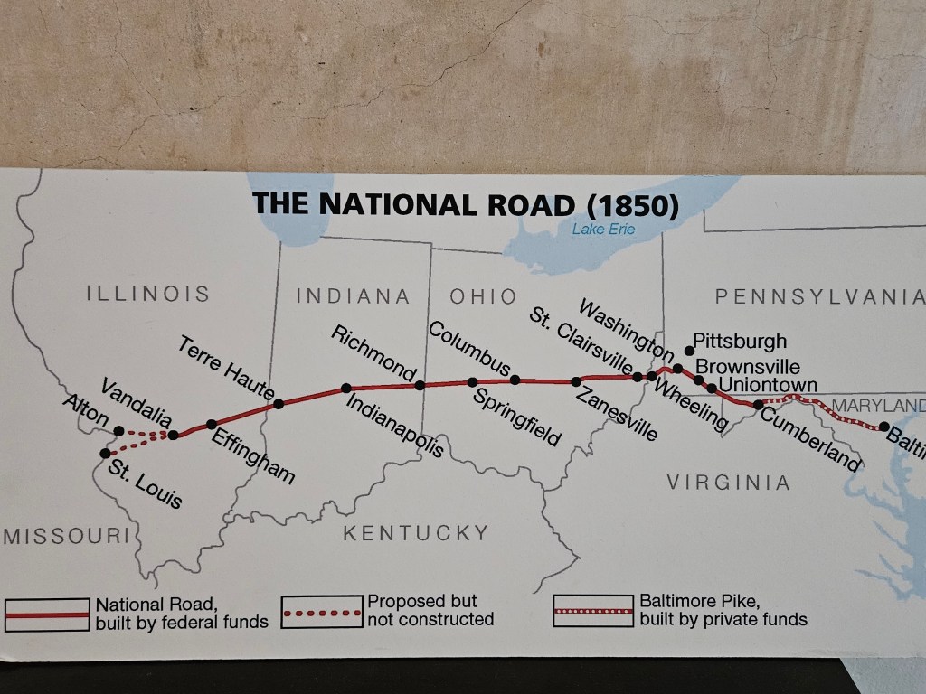
In modern times, this road has been replaced by US State Route 40. Nothing was said about Interstate 70, but it follows the same route.

Mount Washington Tavern is also part of the Ft. Necessity park. It was built in the 1830’s when traffic on the National Road was hopping. People needed sustenance, a place to stay, and a change of horses. It became a stop on the Good Intent stagecoach line.

My only picture of the outside is above, on the side, as I hiked up to it. It’s a 3-story brick structure. I sure could have used a nice cold lemonade about then, owing to the heat and the small hill I’d had to climb, but I was about 200 years too late.

The tavern was the surprise of the day. I knew nothing about it, and tried the door: open. Creeeak! Absolutely no one around. It is self-guided.

A traveler would have come into the main hall. There is a lovely parlor on the left.

Looking to the right, I could see why the parlor had been so nice: it was for women and families. The men would have congregated in the bar.

When a bell was rung, everyone came to dinner in the dining room, family-style, around one big table.

Upstairs, men and women slept in separate bedrooms. It would not have been unusual to share a bed with a stranger. If the sheets had been washed in the past few days, you were lucky.

Your hotel room for the night, 1850’s style. Oh, you wanted a bed to yourself? Sorry, we’re full…

And, I was feeling lucky that I had been born in the latter half of the 20th century. I really enjoyed this peek into the past.

Our time in Ohiopyle was sadly over. It had been a full and enjoyable couple of days, and I was sorry to move on.

More fun was ahead, though, as we moved northward on the National Road and other roads to Lake Pymatuning State Park. This lake straddles the two states of Pennsylvania and Ohio not far south of Lake Erie. We stayed on the Pennsylvania side.

Lake Pymatuning is a lake that is probably much like countless others that dot the Midwest. For me, though, it has some faded memories. When my family lived in a Cleveland suburb, we came here for camping trips in our family tent. I remember swimming with a (real) inner tube and eating tons of my mother’s pancakes, although I may not have the right park in my mind.

Early morning fishing on Lake Pymatuning

We arrived in a downpour. We could not remember the last time we had to set up in the rain. That showed us that our site had excellent drainage. By the next morning, all was clear.

My Dad would pile my brothers into a rented row boat for some fishing. Always a rowboat. I don’t know if motor boats were as much of a thing back then, or if he just didn’t want to pay what I’m sure would have been a higher cost. If I was really lucky, I was invited along. They would give me a little bamboo pole but I don’t remember catching anything.

My family was strictly in the camp of eating whatever we caught. No “catch and release” for us, unless it was “just” a little sunfish. My Dad and brothers would clean the fish and my mother would fry them up for supper. What would she do if there were not enough? I don’t know, she always made plenty to eat.

There was an Amish encampment here with a lot of kids. Perhaps there was more than one family. As I walked by, they had a huge pile of bikes behind their tent. Instead of seats, though, they had skateboard platforms. I’d never seen these before. A young man unwittingly demonstrated how they work as he flew all over the campground.

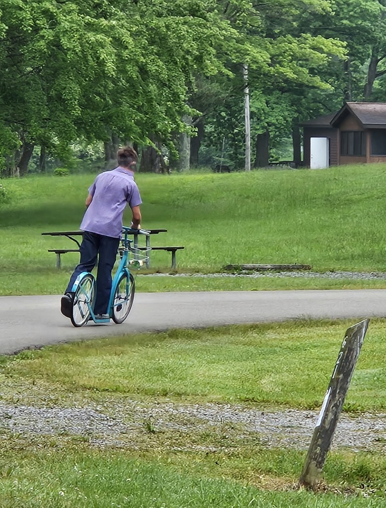
My first thought was, “They’re not even allowed to sit on a bike?” Cal pointed out that it is just better exercise to stand rather than sit, since he had seen these before.

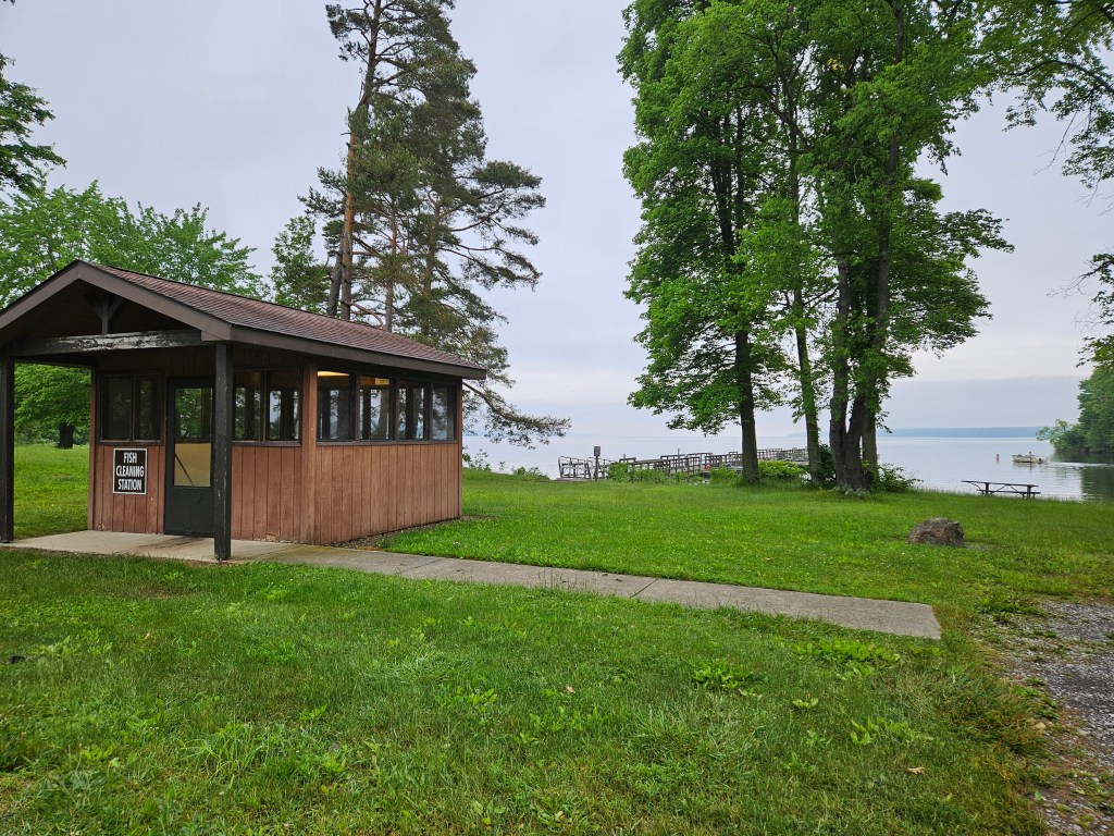
Our stay here was relaxing and idyllic. We were in a smaller, quieter loop than the main one with its beach, playground, dock and fish cleaning station. It looked like folks were mainly local, and a lot of people just had tents.

We did get out a bit. The thing to do is to drive up to the spillway and feed the fish. I did not know what the big deal is about that, but apparently it has gone on for years. The catchphrase is “Where the ducks walk on the fish!”

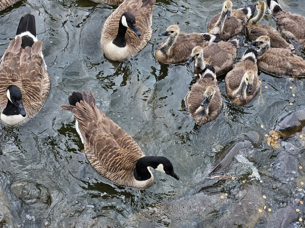
The fish are carp and there were a lot more geese than ducks, but that is something that changes with the seasons. There were SO many geese, and SO many big fat carp all vying for a bit of bread…or Cheerios.

I do not remember my parents bringing us here. My sister Gloria says that our Mom would have used every scrap of her homemade bread in her cooking, and my ever-practical Dad would never have bought us bread just to feed fish and ducks. I would tend to agree. But this was evidently a thing as far back as the 30’s, according to the signboard. You can buy an entire loaf of bread for $1 to feed them. It is a feeding frenzy.

The board also noted that, while it is now known that bread is not the best thing to feed waterfowl and fish, the culture and tradition are being honored. It’s prohibited to do this anywhere else.

We left the fish, and their gaping mouths, and drove along the causeway into Ohio to the little town of Andover for lunch. The main part of the town is on a square. It seems like there should be a courthouse on that square, but there is a nice park instead. The city street goes around the square in one direction. On the edge of the square is a gas station, and behind it and off to the side is the town grocery store. This has the effect of keeping the old town busy, and is brilliant city planning.

We ate lunch at West Side Deli, which is in yellow lettering at the far left of the above picture. We ordered the shrimp basket special, and while we were waiting for lunch a steady stream of customers flowed in. They were giving free hot dogs to the kids. I had gotten into conversation with another customer, and she said for sure it is a once-a-week event, if not more often. It’s really wonderful to see a business supporting the community in this way.

There is also a campground on the Ohio side of Lake Pymatuning, and we drove through it. It is smaller than the Pennsylvania park we were in, but it looks a little more familiar. I’m not sure if this isn’t where my family camped, because it was all too long ago.

At Ohiopyle and Pymatuning, we were at the farthest south and east that we would be on this trip. From here eastward, the only place to go is back to Ohio. And that is a story for next time.

Next time: we visit the Cleveland area, and old friends too

Uncategorized

Rolling through Kansas

It was a little sad leaving the AirBnb in Denver that we had called home for seven months. We had sort of grown to like the place, cramped as it was. We don’t feel cramped in the RV. I don’t know why that is, but we’re very happy to be back in it and on the road again for a journey across the Midwest. First, though, we have to get through Kansas. At our speed that entails three nights.

First stop – a repeat in Goodland at the KOA. Goodland’s claim to fame is the huge Vincent Van Gogh replica painting that stands on a 80-foot high easel. I had Cal take a picture of little me for perspective.

Goodland is a tidy little town, with old houses on quiet streets that you can walk down the middle of and no one would care. On a previous visit we discovered that they have a cute historic downtown area. There’s also a tiny museum which, on the outside of its building, proclaims their other claim to fame: America’s first helicopter was patented here.

This time, we only walked as far as the restored White Eagle Gas Station.

Rod Cooper, who owns the Crazy R’s restaurant in town, moved the gas station as well as historic gas signs here from another location. Every town needs a visionary. His latest project is a huge historic home which he placed right next to the KOA. It’s still a work in progress.

Further down I-70 lies Wilson, Kansas. We discovered Wilson a few years ago when visiting the Garden of Eden in Lucas. Afterward, we had lunch at the “Made from Scratch” diner across from the grain silos in Wilson. It’s only open at lunch time and on certain days. A tradition was born. We try to stop whenever we venture across the Kansas prairie. It’s a good homestyle lunch with great pies and we always enjoy soaking up the local atmosphere: seeing all the farmers coming in to chew the fat with their buddies.

Tiny little Wilson RV Park, where we booked our stay this time, is a bit of a work in progress. Unfortunately we were here on a day when the diner was closed. They have problems finding help. Just when I resigned myself to having our leftovers for dinner, we discovered another Wilson restaurant which sits inside the 1899 limestone Midland Railroad Hotel.

This is called “The Sample Room”, in the basement of the hotel. You could guess that it’s named for attempts to try the samples of alcohol behind the bar. Actually, though, this hotel was once a popular railway stop between Kansas City and Denver. Salesmen would bring samples of their wares down here to try to score a sale. Cal and I watch “Antiques Road Show” and I’ve seen these samples. They are often intricate working miniatures of the real thing: windmills, tractors and other farm implements, as well as household items, which would fit in a small case.

Verdict: I think lunch at the Made from Scratch is more fun, and we love those pies, but our humble little plates of meat loaf and chicken fried chicken at the Sample Room were also delicious. Besides, one place is only open for lunch and the other place is only open for dinner.

Wilson is on the “Post Rock Byway”. Besides the pretty view of the hills and prairie on the road, you can also still see fences made from limestone on this road and also all over western Kansas. You can see two of these antique posts in this prairie view, as well as the modern barely visible windmills on the horizon. The past meets the future.

Early pioneers discovered that wood was not plentiful here, but limestone was. Besides being used for fencing still, these posts are included in landscaping everywhere. There was a pretty little garden outside the hotel using them as the legs for a limestone table. It is on the right in this picture.

Wilson was built by Czech immigrants and has dubbed itself “The Czech Capital of Kansas”. These decorated eggs can be found all over the little downtown area, but this golden one was especially beautiful.

The most fantastical, though, is this: at 20 feet tall, the world’s largest Czech egg:

In a state where all the sights are small-scale, Kansas likes superlatives. North of here, we once went to see the biggest ball of twine in Cawker City. We haven’t seen the world’s largest belt buckle in Abilene yet, though.

This complex consisting of a grain elevator, a office, and a coal storage building dates from 1900. Trains still do blow by here fairly regularly.

Our RV park owner also has a little coffee shop in front. As we stood in line for treats, we spoke to her, and to the owner of “Missile Silo”, which is a decommissioned missile base. There are more things to see around Wilson and a good restaurant in a neighboring town was recommended. I guess we’ll have to come back! Next time, though, I’ll make sure “Made from Scratch” is open.

We waved out the window as we passed Manhattan and Ft. Riley. We lived there many moons ago. A plan to include a visit to our friend Gayle had to unfortunately be scrapped when the itinerary expanded to too many days out.

The last Kansas stop, a new one for us, was Lake Shawnee County park on the west side of Topeka. Everything was paved so it was pretty nice. The campground is above the lake on a little peninsula that juts out into it, so there was water to be seen on both sides. A sunset view over the lake was right out our back window.

It was a good start to the trip, so we are looking forward to continuing eastward.

Next time: biking and Laura I. Wilder in Missouri

Uncategorized · USTravel

Wagons West to California

A lunch stop at the first rest area inside California

I have one note to add before I jump into this post: we are now actually in Denver for the summer. We’re in our RV at the local state parks, and getting ready for a blessed event! Yes, we are expecting our third grandchild within another month, and helping out the busy parents to (literally!) get their house in order by doing a lot of babysitting for the older two. The most traveling that we are doing these days is to shuffle between the two state parks every two weeks.

There are still plenty of memories to record for this trip. Once we were into the month of May in Las Vegas, the weather started getting very warm. Long rows of RV sites at our park stood empty. Did we stay in Vegas too far into the spring? As we traveled through California and beyond, there were times when I thought so. There were other times, though, when I was glad we waited.

Counting Desert Eagle at Nellis Air Force Base in Las Vegas, we had three military RV park stays back to back, with just a one-night stop at a KOA thrown in between for good measure. That’s rare for us. We traveled southwest from Vegas back into California on Interstate 15. We were farther north than we had been earlier in the season, but still traveling through the Mojave Desert. Our second military park was the tiny Marine Logistics Base just east of Barstow.

The black shield in the middle of this marker reads “Barstow 66″ for the legendary road

Cal was very excited about this stop as it was our first Marine Corps base. The only military branch we haven’t stayed with at this point is the Coast Guard. This base once sat on the old Route 66. The RV park wasn’t much, just a solitary road with a dozen or RV sites on either side, but it was OK for a night.

The real reason for being here is that I wanted to go to Peggy Sue’s Diner. I had found it on Harvest Host and it looked like a fun place to eat and then stay for the night. Harvest Host stops already have one strike against them in Cal’s mind, since they don’t have RV hookups. Add in a huge potholed concrete lot on the side of the highway where truckers also like to stop, and that’s two strikes. So, after unhooking truck from RV, we headed out for dinner.

You can’t miss Peggy Sue’s. With billboards back as far as Las Vegas, it is an I-15 institution. The place was opened in 1954, and this is the original diner:

These tables were full, but no worries: there are several more dining rooms. After we found a table and ordered, I was entertained by getting up to look around at all the rock-n-roll memorabilia while I waited for my dinner.

There’s even an outdoor garden:

We indulged our appetite for fried chicken, and the portions were huge enough to take home for another meal and then some. By not eating all of the dinner, we saved room to share a slice of delicious strawberry-rhubarb pie with ice cream.

There’s one more thing to note about this stay: in the morning, we walked over to the commissary for a few groceries. I saw this, for the very first time in my life:

Perhaps you’ve seen these before, especially if you live in California. It is a solar-powered electric charging station. Having one environmentally friendly power source charged by another is brilliant. Perhaps I’m being a bit of an idiot and they are everywhere. Later, in California, we found ones that were much bigger. It’s the wave of the future, recorded here! Is this the first time you’ve seen this?

We’d seen huge solar farms farther south and in Nevada as we’d traveled. The places I’ve lived in the past don’t have enough sun for a solar farm, so for me they are novel.

Moving on further west, there was the usual desert driving, more Joshua trees, and finally we climbed a mountain. At Tehachapi we entered a valley and that was the end of the Mojave Desert. When we parked at the Bakersfield KOA, we had grass on our site. That was a marvel! The grass was so soft. We thought hard about it and decided it was the first grassy site our RV had been parked in since we’d left Colorado the previous November.

We didn’t disconnect truck from RV in Bakersfield, so for some entertainment we walked down to the Camping World store about a quarter of a mile away. Across the road from the KOA were car dealerships lined up, one next to another. Each one had one of these cute little Bakersfield-themed pieces of art in front of them:

After Bakersfield, we entered the Central Valley of California. In the distance we could see barren hills. But in the valley were miles and miles of orchards. I don’t know what kind of trees for sure, but we saw signs for almond and pistachio. There were ranches with cattle and a couple of beautiful flower fields. Closer to Paso Robles, we began to see vineyards and many wineries. Now we turned south and the hills started to close in and become green with a smattering of trees. And then, all the hills became tree covered. Everything was kalaidoscopic green. Having been in the desert for seven months, I felt like we’d reached the Emerald City!

We stayed at a National Guard post outside of San Luis Obispo for several days. Everything looked like it had been built in the 1940’s and not much improved since then. Here, though, we found a place that we absolutely loved. There is only space for 12 RV’s, plus more room for dry camping around the edges, at Camp San Luis Obispo. The sites are wide and grassy. The whole time we were here there were probably less than five other RV’s sharing the park with us, plus the camp host.

Here’s a view to the green hills of San Luis Obispo:

An afternoon bike ride here felt like a ride through the countryside. And back at our site, there was plenty of wildlife to entertain us: a whole scurry of ground squirrels that resided in the field behind us, one or two deer strolling through, and a pair of turkeys that regularly visited.

On the last couple of days of our stay, a marine layer (fog) crept in over the hills, for the ocean was just on the other side.

We are learning that all of the military branches have diverse places to stay across the US. But near San Luis Obispo there are other places for RVer’s to stay. Why would anyone want to come here? I’ll explain in my next two blogs.

Next time – the Pacific seaside near San Luis Obispo